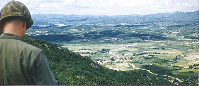
An edited version of this photo is now being used at the top of the Korean War Educator
Web site and on the entrance page to the site. We wanted to show the original unedited photo.
The panoramic photo was taken in April, 1953, on the western front from Hill 209, by Dr. Birney Dibble.
At the time, Hill 209 was being held by George Company, Third Battalion, Fifth Marine Regiment, First Marine
Division. The panorama in the distance includes the "Nevada Hills" (Reno, Carson, etc) and Hill 229 which
was called Paehok-san. The "Marine" in the photo was actually Navy doctor Frank Folk, who had just come to
Easy Med to relieve Dibble of his command. Dibble had been in Korea since Dec of 1951 and was finally going
home. Dr. Folk was a lieutenant, senior grade, in the Navy Medical Corps at the time. According to Dr.
Dibble, "He had come down from the battalions to take over my position as commanding officer of Easy Medical
Company of the First Marine Division, and I was showing him around the area. Incidentally, the first
hill on the other side of the flat plain is Bunker Hill."
Frank Folk had an illustrious career after getting out of the Navy. He specialized in general surgery and
stayed in the Chicago area. There, he became Professor of Surgery at Loyola University. Later, he became
Chief of Surgery at Cook County Hospital, and subsequently at the VA Hospital, Hines, Illinois.
---
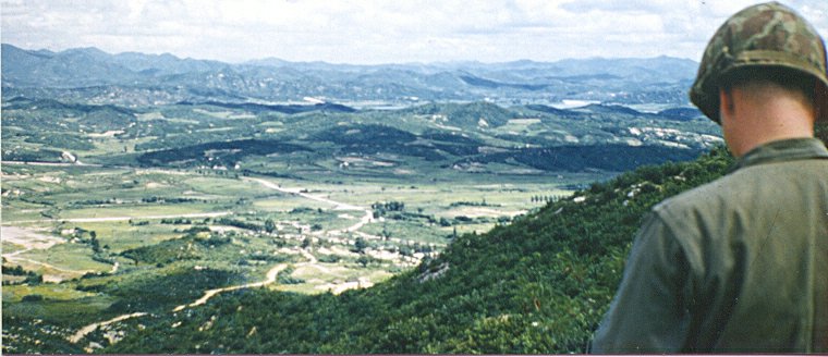
Viewer Jim Johnson (Marine 1951-1977) sent this message from the "western edges of the Ozark plateau" to
the KWE in October of 2010:
"After hours of review of the landscape color photo on your lead page, attempting to organize my
thoughts and contour lines, I finally discovered the source of my difficulty. The negative of the
photo is backward and I stood exactly where our 3rd Battalion, 5th Marine MD was standing, as a member of
G/3/5 from November 1952-November 1953. I have spent untold hours attempting to place this area on a
1947 map of the area and finally I discovered the negative was reversed. How did I determine this?
The helmet chin strap which is shown on the M-1 helmet is wrong. The long tab is on the right and
the short tab is always on the left. The photo shows just the opposite; therefore the negative is
reversed."
In a second e-mail, Johnson continued:
"I was involved in the Reno Vegas Carson event. We, G/3/, had been on the MLR in January in
basically the same place and the 3rd Battalion had all three OPs. We were relieved in mid to late
February 1953, went to the rear, and were back in basically the same positions as in January, for the
R/C/V event.
I have walked all over the area described and shown in the photo. Of course, it was dark, really
dark, and scary on most nights. I have a couple of unit-made maps that show the approach from the
MLR to the three OPs and the Block. But I could never get your photo oriented to the real world.
I've probably spent 50-75 hours "playing" with the lay of the land and the contour lines.
After I discovered that the helmet image was reversed, the short strap is always on the left and the
long strap always on the right, was different in the photo, I realized that the negative was reversed!
The short strap on the left allowed the Marine to quick release his helmet with his left hand while having
a weapon in the right hand. Interesting point: What if the Marine was left-handed and had his weapon
in the left hand...so goes life!
So to prove my point, I copied the photo, reversed the photo negative and "Wow!" the contour lines were
a match for my maps and the 1947 map of the area."
|